Titan SCP is a networked distributed processing platform for surveying and remote sensing data production. It adopts international advanced scheduling and computing workflow technology to integrate production, management, scheduling, monitoring and quality control into one.
Product description
Titan SCP is a networked distributed processing platform for surveying and remote sensing data production. It adopts international advanced scheduling and computing workflow technology to integrate production, management, scheduling, monitoring and quality control into one. The bigger scale aerospace data can quickly generate high-precision products such as digital surface models, digital elevation models, digital orthophotos, and real-life three-dimensional models.
Based on the microservice architecture design, 4.0 platform is a new remote sensing application model centered on cloud computing and the Web, enabling users to access platform resources and functions anytime and anywhere using a variety of terminals. On the basis of satellite and aerial image functions, radar, laser point cloud and tilting aerial image processing procedures have been added, which has become an all-round support platform for surveying and mapping remote sensing sensors.
Features
● Intelligent and efficient scheduling
Intelligent project management and task scheduling realize production, management, scheduling, monitoring, and quality control, rationally allocate computing resources and human resources, and maintain overall system load balancing. The new micro-service architecture 4.0 introduces an automatic service discovery mechanism, fully adapts to the automated deployment requirements in cloud and container environments, and easily implements distributed cluster system deployment, maintenance, and diagnostics.
● Scientific computing workflow
Provide WYSIWYG process editing tools, support users to customize the complex structure process such as sequence, condition, loop, branch, etc. according to specific tasks, seamlessly integrate automated large-scale computing with manual interaction processing to form “one-click” processing.
● Complete system expansion mechanism
The open architecture framework provides convenient third-party algorithm and application integration capabilities to support high-performance/high-throughput computing in different domains. Various professional processing algorithms can be customized and deployed in the form of plug-ins to run in the system.
● Ready-to-use web console
Providing a ready-to-use remote sensing service for users, users only need a thin client such as a web browser or a mobile device to perform complex and resource-intensive operations on images, and can obtain the progress and results of data processing services anytime and anywhere.
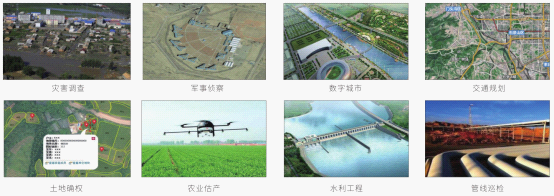
Functions
● Aerial image processing: aerial image air three adjustment, orthorectification, dense matching, DEM / DOM production.
● Satellite image processing: multi-star image combined with regional network adjustment, DSM automatic extraction, orthorectification, image fusion, etc.
● Radar image processing: interference image registration, wave filtering, image bit unwrapping, SAR area network adjustment, DEM extraction, orthorectification.
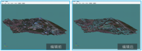
● Laser point cloud processing: point cloud preprocessing, visualization and editing, point cloud filtering and classification, DEM generation, orthorectification, point cloud data vector collection and 3D reconstruction.
● Uniform color uniformity: Provides automatic color uniformity and monochromatic uniformity based on color constraints to achieve large-area color consistency processing in “one-click mapping”.
● Image parallel mosaic and editing: Make full use of the cluster's super-computing ability, multi-node parallel block reading and writing, can complete TB-level image seamless mosaic in tens of minutes.
● Automatic reconstruction of 3D modeling: tilting aerial image space three encryption, dense matching, building TIN network, generating white mode (DSM), texture mapping, etc., reconstructing the real three-dimensional model of the ground.

![]() CHINA TECH HI INDUSTRY IMPORT & EXPORT CORP. (CTHC) is a company specialized for import & export founded in 1993 at the authorization of the Chinese Ministry of Foreign Trade and Economic cooperation.
CHINA TECH HI INDUSTRY IMPORT & EXPORT CORP. (CTHC) is a company specialized for import & export founded in 1993 at the authorization of the Chinese Ministry of Foreign Trade and Economic cooperation.
![]() Pragmatism
Pragmatism
![]() Efficiency
Efficiency
![]() Solidarity
Solidarity
![]() Striving
Striving


 Search
 Current position >
  Inquiry
  Favorites